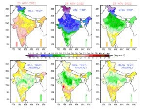
Winter started stretching its legs across the country over the past week when night temperatures have plummeted to the season’s lowest so far in multiple cities in India.
It was a cold start of the week when Santacruz Observatory in Mumbai recorded 17.0°c minimum temperature on 21 November anomalies 4°c below normal, also became the monthly lowest recorded minimum temperature over the last six years, the previous lowest was 16.3°c from 11 November, 2016.
In the presence of the cold winds from north India, most parts of Deccan observed cold nights and mornings. Pune recorded the season’s lowest minimum temperature at 8.8°c on 21 November, also it was the coldest morning in the last decade for the month of November, previous lowest minimum temperature was observed as 7.9°c on 19th November, 2012.
Bangalore too experienced the coldest morning after 2012 by registering 13.9°c minimum temperature on 21 November.
Later as the week progressed the low pressure area from the Bay of Bengal influenced the weather in most states in the peninsula, bringing rainy weather in various parts of Tamil Nadu, Andhra Pradesh, Goa, Karnataka and Kerala.
Rainfall on 24 November in North Tamil Nadu from the low pressure area
Thamaraipakkam: 100mm
Tiruttani: 71mm
Poondi: 36mm
Uthukottai: 33mm
Thervoykandigai: 32mm
Tiruttani PTO: 26mm
Cholavaram: 24mm
Tiruvallur: 23mm
Thiruvalangadu: 21mm
Pallipattu: 19mm
Ponneri: 15mm
Kadambathur: 14mm
Tirur: 11mm
Avadi: 10mm
Vellore
Gudiyatham Agro: 63mm
Madhanur: 48mm
Gudiyatham: 43mm
Melalathur: 40mm
Peranampattu: 21mm
Katpadi: 17mm
K.V.Kuppam: 16mm
Virinjipuram: 15mm
Kaniyambadi: 13mm
Ammundi: 12mm
Vellore: 10mm
Tiruvalam: 10mm
Nariyampattu: 10mm
Chennai
New Manali Town: 51mm
Ennore: 47mm
Kathivakkam: 29mm
Ice House: 21mm
Collectorate; 19mm
Royapuram: 10mm
MRC Nagar: 10mm
Redhills: 10mm
Rainfall in Visakhapatnam during the span of 24 hours on 25 November in the wake of low pressure area from bay of Bengal:
Ushodaya Circle: 57mm
Sagar Nagar: 55mm
Zoo Park: 55mm
Madhurawada: 44mm
Anandapuram: 40mm
Arilova: 34mm
Vuda Park: 33mm
Bheemili: 31mm
Maharanipeta: 22mm
GVMC office: 20mm
Gajuwaka: 7mm
The weather system pushed in moist easterlies winds across the peninsula and winter like conditions abated from most parts, From 8.8°c on Monday to 19.1°c on Saturday an exceptional rise in minimum temperature was observed in Pune, similarly Mumbai recorded 23.0°c on 26 November both had 6°c and 3°c above normal minimum temperatures.
The weather in Madhya Pradesh, Chhattisgarh, Gujarat remained clear and dry across the week with cold nights setting in the region.
Most states in India’s North East experienced dry weather conditions with temperature in varied ranges, also states in East India like Bihar, Jharkhand, Odisha, West Bengal observed another dry and pleasant week.
Winters have knocked the doors of North India as we are already at the end of November, temperatures kept plummeting to the season’s Lowest at most stations and records have already started tumbling down.
National Capital New Delhi’s Safdarjung observatory recorded 7.8°c on Thursday morning making it the coldest morning of the season so far.
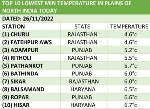
Nights are fairly cold across Punjab, Haryana, Delhi NCR, UttarPradesh and Rajasthan as minimum temperatures are in single digits and below normal but clear weather in the day is keeping maximum temperature’s as high as 27 to 28 degree celsius and up to 30°c in parts of Rajasthan making it not so cold in the day-time.
Season’s first cold wave spell hit parts of Rajasthan and West Rajasthan in the past three days,
Kota recorded a minimum temperature of 8.5°c on Thursday morning which was 7.0° below normal,
This is the lowest recorded temperature in the month of November at least in the last one decade in Kota.
Meanwhile the all time low is 2.8°c from 18th November 1926.
At the same time Churu Shivers at 4.1°c on Thursday morning, 5.0°c below climatological average.
On Sunday morning Jodhpur in Thar desert recorded 9.9°c minimum temperature.In the last decade this is only the second time temperature fell to single digits in the month of November in Jodhpur.

When is the cold wave declared?
Based on daily maximum/ minimum temperature station data, climatology of maximum/ minimum temperature is prepared for the period 1981-2010 to find out the normal maximum/ minimum temperature of the day for a particular station.
It is based on the actual minimum temperature of a station; a cold wave is only considered when the minimum temperature of a station is 10°c or less for the plains and 0°c or less for the hilly regions.
The departure from normal must be -4.5°c to -6.4°c to declare cold wave conditions, in case of departure from normal is more than -6.4°c severe cold wave must be declared.
Another terminology is described by the Indian Meteorological Department to declare a cold wave is irrespective of the departure from normal when the minimum temperature is below or equal to 4°c coldwave is to be declared, Severe cold wave is coined when minimum temperature dips below 2°c.
Srinagar records coldest night of the season with minimum temperatures falling at minus 2.1 degrees celsius on Sunday morning.
Minimum temperature in Kashmir region till 27 November:
Srinagar: 2.1°c
Qazigund: 1.4°c
Pahalgam:3.4°c
Kupwara: 1.4°c
Kokernag: 0.4°c
Gulmarg: 1.0°c
Anantnag: 1.3°c
Baramulla: 0.8°c
Ladakh:
Leh: 7.8°c
Kargil: 7.5°c
Drass: 11.9°c
Thoise: 5.2°c
Base Camp: 10.2°c
Grakone: 2.2°c
Khaltse: 5.2°c
Padum: 16.8°c
Diskit Nubra: 7.5°c
Chuchot Yokma: 9.1°c
Upshi: 8.9°c
Tangtse Durbuk: 11.2°c
Nyoma: 12.6°c
Hanle: 8.4°c

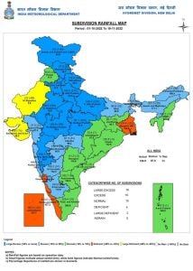
Subdued rains in South India resulted in fall in overall rainfall numbers in the country but the departure from normal is holding above the ‘normal’ category,
In the period of 1 October till 27 November, India received 128.4mm rainfall against the normal of 102.3mm, a departure from normal stands at +25%.
Subdivision wise seasonal rainfall figures
- Southern Peninsula: Actual 234.8 mm against the average of 235.3 mm, 0% departure from normal.
- East & North East India: Actual 164.8 mm against the average of 143.6 mm, +15% departure from normal.
- North West India: Actual 79.5 mm against the average of 31.8 mm, +150% departure from normal.
- Central India: Actual 93.5 mm against the average of 69.5 mm, +35% departure from normal.

Current synoptic features influencing weather in India as on 27 November:
- The cyclonic circulation over Southeast Arabian Sea & neighbourhood extending up to 3.1 km above mean sea level persists.
- The cyclonic circulation over East Central Bay of Bengal & adjoining North Andaman Sea extending up to 4.5 km above mean sea level persists.
All India weather forecast till 3 December:
North, Central, East and North East India:
Following the trend of the previous week, dry and clear weather conditions are likely to prevail across the Himalayas, North, Central, East and North East India in the upcoming week.
Precipitation in these days depends on the western disturbance which is not seen anytime in the near future, ensuring that dry weather will be dominating large parts of the country till 3 December.
Since there is no atmospheric disruption cold winds from the north west will remain uninterrupted across the next week.
Meanwhile the potential cold wave will continue to impact parts of Rajasthan, Punjab and Haryana during the morning hours in the upcoming week as minimum temperature to remain stable and may fell further by 1 to 2 degree celsius as we head into December, Also the maximum temperatures will remain stagnant resulting in lack of feel-cold factor in the afternoon hours.
No rains and less moisture conditions will not let foggy conditions to appear over the plains of North India, maximum temperatures do not usually start falling until fog formations start in the winters.
Dry and slightly warm weather across the afternoons and cool nights are expected in Gujarat, Maharashtra, Madhya Pradesh, Chhattisgarh, Bihar, Jharkhand, Odisha, West Bengal and states of North East India till 3rd December, winter conditions will not be taking any severe turn for another week.
Expected range of minimum and maximum temperature in the States till 3rd December:
- Punjab: 4 to 10°c, 23 to 27°c.
- Haryana: 5 to 11°c, 23 to 28°c.
- Delhi NCR: 7 to 12°c, 24 to 28°c.
- Uttar Pradesh: 7 to 12°c, 25 to 30°c.
- Rajasthan: 3 to 13°c, 26 to 32°c.
- Gujarat: 9 to 17°c, 27 to 34°c.
- Madhya Pradesh: 6 to 12°c, 26 to 33°c.
- Maharashtra: 8 to 18°c, 27 to 34°c.
- Chhattisgarh: 7 to 14°c, 27 to 33°c.
- Bihar: 7 to 12°c, 25 to 31°c.
- Jharkhand: 8 to 14°c, 27 to 32°c.
- West Bengal: 10 to 18°c, 28 to 34°c.
- Odisha: 9 to 15°c, 28 to 34°c.
- North East India: 3 to 14°c, 21 to 34°c.
South India:
The north east monsoon performance over the last week has been largely disappointing in terms of the rainfall performance, following the trend – upcoming week is most likely to be another less performing in terms of rainfall activities.
The low pressure areas from the bay of bengal which are termed as the core driver of the north east monsoon will remain absent for next seven days, in absence of tropical developement rainfall activities in Tamil Nadu, Kerala, Andhra Pradesh and Karnataka is likely to localised and based on local factors till 3 December.
Slowly the rainfall departure from Normal will start falling to negative in the upcoming days for the southern states as the rainfall remains subdued for another one week.
Expected rainfall in South India till 3 December:
Tamil Nadu: 20mm
Andhra Pradesh: 20mm
Kerala: 20mm
Karnataka: 10mm
Telangana: 5mm
Goa: 0mm
The author, better known as the Rohtak Weatherman, interprets and explains complex weather patterns. His impact-based forecasts @navdeepdahiya55 are very popular in north India.
Read all the Latest News, Trending News, Cricket News, Bollywood News,
India News and Entertainment News here. Follow us on Facebook, Twitter and Instagram.
from Firstpost India Latest News https://ift.tt/mE0KvHy


0 Comments